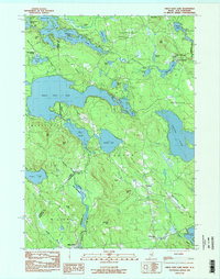
1983 Map of Great East Lake
USGS Topo · Published 1984About this map
Great East Lake and Wilson Lake dominate this survey of the borderlands between Maine and New Hampshire. The landscape is defined by its complex hydrology, where the Salmon Falls River and Little Ossipee River drain a terrain of prominent heights like Hubbard Ridge and Acton Ridge. Small settlements and rural crossroads provide a glimpse into the late-20th-century community structure of York County, with Acton and North Shapleigh serving as local hubs. The map reveals a mix of recreational and industrial use, from the residential clusters at Shady Nook and McCutcheon Corners to the Sand & Gravel Pit operations near the lakes. Genealogists may find interest in the documented locations of the Highland Grove Cemetery and the Maple Grove Church near South Acton, while the presence of the Mellon Airport indicates the regional infrastructure of the early 1980s.
Find a feature on this map
60 named features on this map. Tap any name to fly to it.
Don’t see what you’re looking for? This feature index may not catch every label — zoom into the map to look around manually.
Map Details
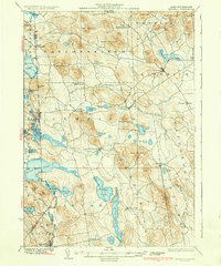
Editions of this 1983 Great East Lake Map
2 editions found

Other maps of this area

1891 · Berwick
USGS Topo · 1:62,500

1891 · Newfield
USGS Topo · 1:62,500

1893 · Berwick
USGS Topo · 1:62,500

1893 · Newfield
USGS Topo · 1:62,500

1919 · Alton
USGS Topo · 1:62,500

1928 · Wolfeboro
USGS Topo · 1:62,500

1933 · Berwick
USGS Topo · 1:48,000

1933 · Newfield
USGS Topo · 1:48,000
1937 · Newfield
USGS Topo · 1:62,500
1937 · Berwick
USGS Topo · 1:62,500