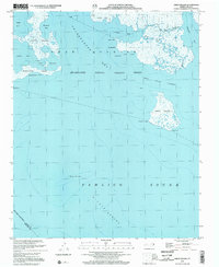
2002 Map of Great Island
USGS Topo · Published 2002About this map
Swanquarter National Wildlife Refuge dominates this coastal landscape, protecting a labyrinth of marshlands and brackish inlets where Swanquarter Bay meets the vast Pamlico Sound. This environment is defined by its complex hydrography, featuring isolated landmasses like Judith Island and Great Island, separated by tidal channels such as Great Island Narrows and Shell Narrows.
Find a feature on this map
32 named features on this map. Tap any name to fly to it.
Don’t see what you’re looking for? This feature index may not catch every label — zoom into the map to look around manually.
Map Details
Editions of this 2002 Great Island Map
This is the sole edition of this map. No revisions or reprints were ever made.
Other maps of this area

1951 · Brant Island
USGS Topo · 1:24,000
1951 · Bluff Point
USGS Topo · 1:24,000

1951 · Pamlico Point
USGS Topo · 1:24,000

1951 · Great Island
USGS Topo · 1:24,000

1951 · Scranton
USGS Topo · 1:24,000

1951 · New Holland
USGS Topo · 1:24,000

1951 · Swanquarter
USGS Topo · 1:24,000

1953 · Rocky Mount
USGS Topo · 1:250,000

1954 · Rocky Mount
USGS Topo · 1:250,000
1985 · Bayboro
USGS Topo · 1:100,000