
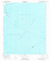
1951 Map of Brant Island
USGS Topo · Published 1951About this map
Pamlico Sound dominates this mid-century coastal survey, capturing the intricate hydrography where the brackish waters meet the marshlands of eastern North Carolina. The map illustrates the shoreline of Cedar Island and the expansive Hunting Quarters, a region defined by its reliance on the sound and its diverse network of inlets and points. The inclusion of hydrographic data from surveys dating back to 1866 alongside 1948 aerial photography provides a unique layered view of the shifting coastal morphology. Named features like Brant Island and Sow Island stand as markers in the shallow sound, while the detailed labeling of points such as Oyster Creek Point and Big Fishing Point reflects the maritime navigation and fishing economy central to the local way of life. The boundary between Pamlico and Carteret Counties is clearly delineated as it cuts through the tidal landscape.
Find a feature on this map
22 named features on this map. Tap any name to fly to it.
Don’t see what you’re looking for? This feature index may not catch every label — zoom into the map to look around manually.
Map Details
Editions of this 1951 Brant Island Map
2 editions found
Other maps of this area

1948 · North Bay
USGS Topo · 1:24,000

1949 · Point Of Marsh
USGS Topo · 1:24,000

1950 · North Bay
USGS Topo · 1:24,000

1950 · Point Of Marsh
USGS Topo · 1:24,000

1950 · Lowland
USGS Topo · 1:24,000

1950 · Jones Bay
USGS Topo · 1:24,000

1951 · Broad Creek
USGS Topo · 1:24,000

1951 · Pamlico Point
USGS Topo · 1:24,000

1951 · Great Island
USGS Topo · 1:24,000

1953 · Rocky Mount
USGS Topo · 1:250,000