
1951 Map of Broad Creek
USGS Topo · Published 1951About this map
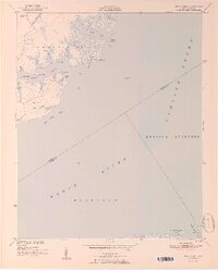
Florence and Alice serve as the primary landward anchor for this coastal survey of the lower Neuse River and Pamlico Sound. The landscape is dominated by the intricate interplay of water and marsh, particularly within Township No 2, where numerous finger-like waterways such as Pittman Creek, Burton Creek, and Parris Creek carve into the shoreline. These creeks surround distinctive points of land like Grace Point and Skate Point, illustrating the natural drainage patterns of Carteret County before modern development.
Find a feature on this map
36 named features on this map. Tap any name to fly to it.
Don’t see what you’re looking for? This feature index may not catch every label — zoom into the map to look around manually.
Map Details
Editions of this 1951 Broad Creek Map
4 editions found
Other maps of this area

1948 · Oriental
USGS Topo · 1:24,000

1949 · Point Of Marsh
USGS Topo · 1:24,000

1949 · Long Bay
USGS Topo · 1:24,000

1949 · Merrimon
USGS Topo · 1:24,000

1949 · South River
USGS Topo · 1:24,000

1950 · Long Bay
USGS Topo · 1:24,000

1950 · South River
USGS Topo · 1:24,000

1950 · Point Of Marsh
USGS Topo · 1:24,000

1950 · Vandemere
USGS Topo · 1:24,000

1950 · Jones Bay
USGS Topo · 1:24,000