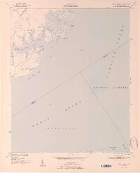
1951 Map of Broad Creek
USGS Topo · Published 1951About this map
The confluence of the Pamlico Sound and the Neuse River dominates this coastal landscape in the early 1950s. The shoreline is defined by intricate tidal fingers like Swan Creek and Broad Creek, which carve into the marshy terrain of Township No 2. Near the northern border, small signs of community life appear at Alice and around the Florence Sch, where the Zion Hill Ch serves the local population. The map reveals the extensive wetlands of the Hunting Quarters and Merrimon districts, areas where the land gradually yields to the water at points like Turnagain Bay Spit. This 1951 edition highlights a maritime economy and lifestyle where names like Gum Thicket Shoal and Skate Point indicate the long-standing relationship between the residents and these shallow, productive waters.
Find a feature on this map
38 named features on this map. Tap any name to fly to it.
Don’t see what you’re looking for? This feature index may not catch every label — zoom into the map to look around manually.
Map Details
Editions of this 1951 Broad Creek Map
4 editions found

Other maps of this area

1948 · Oriental
USGS Topo · 1:24,000

1949 · Point Of Marsh
USGS Topo · 1:24,000

1949 · Long Bay
USGS Topo · 1:24,000

1949 · Merrimon
USGS Topo · 1:24,000

1949 · South River
USGS Topo · 1:24,000

1950 · Long Bay
USGS Topo · 1:24,000

1950 · South River
USGS Topo · 1:24,000

1950 · Point Of Marsh
USGS Topo · 1:24,000

1950 · Vandemere
USGS Topo · 1:24,000

1950 · Jones Bay
USGS Topo · 1:24,000