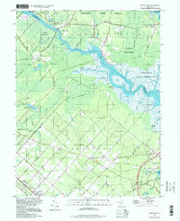
1997 Map of Green Bank
USGS Topo · Published 1998About this map
The Mullica River and its labyrinth of tributaries like Negro Creek and Cedar Cr define this pocket of the New Jersey Pine Barrens. The landscape is a transition from the dense woodlands of Wharton State Forest to the marshy coastal environment of the Swan Bay State Wildlife Management Area. Historic riverside settlements such as Lower Bank and Sweetwater are juxtaposed with the rigid grid of Egg Harbor City, where streets like Bremen Avenue and Antwerp Ave reflect the community’s German heritage. Genealogists can locate family sites at the Germania Cemetery or the Clarks Mill Burying Ground near Port Republic. The map also captures local landmarks like Snyder Sch, providing a detailed look at the rural and municipal infrastructure of Atlantic and Burlington Counties toward the end of the 20th century.
Find a feature on this map
79 named features on this map. Tap any name to fly to it.
Don’t see what you’re looking for? This feature index may not catch every label — zoom into the map to look around manually.
Map Details
Editions of this 1997 Green Bank Map
This is the sole edition of this map. No revisions or reprints were ever made.
Other maps of this area

1887 · Atlantic City
USGS Topo · 1:62,500

1888 · Little Egg Harbor
USGS Topo · 1:62,500

1890 · Great Egg Harbor
USGS Topo · 1:62,500

1890 · Mullica
USGS Topo · 1:62,500

1893 · Great Egg Harbor
USGS Topo · 1:62,500

1893 · Little Egg Harbor
USGS Topo · 1:62,500

1894 · Atlantic City
USGS Topo · 1:62,500

1894 · Mullica
USGS Topo · 1:62,500

1898 · Mullica
USGS Topo · 1:62,500

1900 · Rancocas
USGS Topo · 1:125,000
Featured Places
- Galloway Township, NJ
- Mullica Township, NJ
- Egg Harbor City, NJ
- Bass River Township, NJ
- Port Republic, NJ