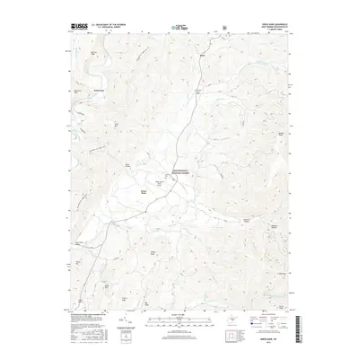
2016 Map of Green Bank
USGS Topo · Published 2016About this map
Green Bank and Arbovale sit at the center of this mountain landscape, defined by a scientific and aviation presence within the Monongahela National Forest. The NRAO Green Bank Airport and Deer Creek Farm Airport highlight the specialized utility of the relatively flat valley floor between the ridges of the Allegheny Mountains. The northern section of the map follows the Greenbrier River as it winds past Hosterman and Boyer, supported by numerous tributaries like Deer Creek and Buffalo Run. Researchers can identify genealogical markers at the Arbovale Cem, while hikers can trace the Allegheny Trail; Marlin Mountain route along the western ridges. The terrain transitions from the Deer Creek Valley to prominent heights such as Old House Knob and Asbury Knob, showing the relationship between small settlement clusters and the surrounding protected wilderness.
Find a feature on this map
51 named features on this map. Tap any name to fly to it.
Don’t see what you’re looking for? This feature index may not catch every label — zoom into the map to look around manually.
Map Details
Editions of this 2016 Green Bank Map
This is the sole edition of this map. No revisions or reprints were ever made.
Other maps of this area

1889 · Beverly
USGS Topo · 1:125,000

1892 · Beverly
USGS Topo · 1:125,000

1901 · Monterey
USGS Topo · 1:125,000

1922 · Spruce Knob
USGS Topo · 1:48,000

1922 · Cass
USGS Topo · 1:48,000

1922 · Durbin
USGS Topo · 1:48,000

1924 · Cass
USGS Topo · 1:62,500

1924 · Durbin
USGS Topo · 1:62,500

1924 · Spruce Knob
USGS Topo · 1:62,500

1941 · Monterey
USGS Topo · 1:62,500