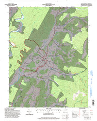
1995 Map of Green Bank
USGS Topo · Published 1998About this map
The National Radio Astronomy Observatory dominates this portion of the Monongahela National Forest, showcasing a unique intersection of high-technology science and rural Appalachian life. Near the settlements of Green Bank and Arbovale, specialized infrastructure such as the Interferometer Range and multiple Telescopes are scattered throughout the valley of Deer Creek. This area, tucked between Allegheny Mountain and Buffalo Ridge, maintains its traditional character through numerous landmarks like Hevener Ch, Liberty Ch, and the local High Sch. To the northwest, the Greenbrier River passes through Hosterman, while the surrounding terrain is marked by prominent peaks such as Asbury Knob and Old House Knob. The map illustrates the careful placement of sensitive scientific equipment within a landscape of established family farms and small mountain communities.
Find a feature on this map
53 named features on this map. Tap any name to fly to it.
Don’t see what you’re looking for? This feature index may not catch every label — zoom into the map to look around manually.
Map Details
Editions of this 1995 Green Bank Map
This is the sole edition of this map. No revisions or reprints were ever made.
Other maps of this area

1889 · Beverly
USGS Topo · 1:125,000

1892 · Beverly
USGS Topo · 1:125,000

1901 · Monterey
USGS Topo · 1:125,000

1922 · Spruce Knob
USGS Topo · 1:48,000

1922 · Cass
USGS Topo · 1:48,000

1922 · Durbin
USGS Topo · 1:48,000

1924 · Cass
USGS Topo · 1:62,500

1924 · Durbin
USGS Topo · 1:62,500

1924 · Spruce Knob
USGS Topo · 1:62,500

1941 · Monterey
USGS Topo · 1:62,500