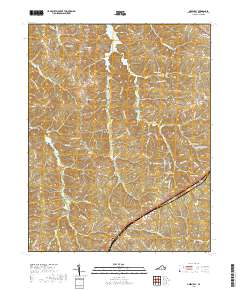
2019 Map of Green Bay
USGS Topo · Published 2019About this map
Green Bay and the surrounding Prince Edward County landscape are defined by a complex network of tributaries feeding the Sandy River and Little Sandy Cr. This modern survey reveals a region where traditional crossroads and small settlements like Moran persist alongside protected waters and recreational spaces. The terrain is punctuated by the prominent Leigh Mtn in the west, while the eastern portion of the quadrangle features a concentration of small reservoirs, including Goodwin Lake, Moores Lake, and Prince Edward Lake.
Find a feature on this map
84 named features on this map. Tap any name to fly to it.
Don’t see what you’re looking for? This feature index may not catch every label — zoom into the map to look around manually.
Map Details
Editions of this 2019 Green Bay Map
This is the sole edition of this map. No revisions or reprints were ever made.
Other maps of this area

1891 · Farmville
USGS Topo · 1:125,000

1893 · Farmville
USGS Topo · 1:125,000

1947 · Roanoke
USGS Topo · 1:250,000

1958 · Farmville
USGS Topo · 1:62,500

1958 · Jetersville
USGS Topo · 1:62,500

1958 · Crewe
USGS Topo · 1:62,500

1958 · Keysville
USGS Topo · 1:62,500

1959 · Roanoke
USGS Topo · 1:250,000

1963 · Roanoke
USGS Topo · 1:250,000
1968 · Farmville
USGS Topo · 1:24,000