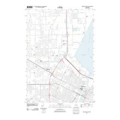
2010 Map of Green Bay West
USGS Topo · Published 2010About this map
The Fox River and its confluence with Green Bay anchor this 2010 survey of northeastern Wisconsin, documenting the urban expansion and coastal infrastructure of the city and its surrounding villages. The landscape is defined by the winding course of Duck Creek and Beaver Dam Creek, which flow through the western suburbs near Howard. Significant local history and genealogy interest is found in the clustered burial grounds, including Saint Johns Cemetery, Fort Howard Cemetery, and Ashwaubenon Cemetery. The map captures a mix of residential growth and critical transit hubs, from the John Antonneau Memorial Airport and Plainview Landing Strip to the maritime activity at Docks and Anchorage Marina. Local landmarks such as Elm Tree Corners, Cormier, and the Oneida Golf Course illustrate the community's layout before more recent developments altered the suburban and shoreline character of the region.
Find a feature on this map
61 named features on this map. Tap any name to fly to it.
Don’t see what you’re looking for? This feature index may not catch every label — zoom into the map to look around manually.
Map Details
Editions of this 2010 Green Bay West Map
This is the sole edition of this map. No revisions or reprints were ever made.
Other maps of this area

1954 · De Pere
USGS Topo · 1:62,500

1954 · Green Bay West
USGS Topo · 1:24,000

1954 · Denmark
USGS Topo · 1:62,500

1954 · De Pere
USGS Topo · 1:24,000

1954 · New Franken
USGS Topo · 1:62,500

1954 · Green Bay East
USGS Topo · 1:24,000

1954 · Manitowoc
USGS Topo · 1:250,000

1954 · Bellevue
USGS Topo · 1:24,000

1954 · Green Bay
USGS Topo · 1:62,500

1955 · Green Bay
USGS Topo · 1:250,000