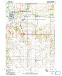
1992 Map of Green Rock
USGS Topo · Published 1992About this map
The Rock River and the Hennepin Canal define the northern landscape of this region, where the historic waterway transition into the Hennepin Canal Parkway is clearly documented. Industrial activity is concentrated near the river valley, with several quarries, sandpits, and a gravel pit indicating the local extraction economy. Further south, the terrain shifts from the floodplains of the Green River into the more dissected uplands of Western and Edford townships, drained by Mineral Creek.
Find a feature on this map
48 named features on this map. Tap any name to fly to it.
Don’t see what you’re looking for? This feature index may not catch every label — zoom into the map to look around manually.
Map Details
Editions of this 1992 Green Rock Map
This is the sole edition of this map. No revisions or reprints were ever made.
Other maps of this area

1892 · Leclaire
USGS Topo · 1:62,500

1893 · Leclaire
USGS Topo · 1:62,500

1899 · Clinton
USGS Topo · 1:125,000

1934 · Geneseo
USGS Topo · 1:62,500

1937 · Orion
USGS Topo · 1:62,500

1949 · Coal Valley
USGS Topo · 1:24,000

1949 · Silvis
USGS Topo · 1:24,000

1949 · Port Byron
USGS Topo · 1:24,000

1950 · Port Byron
USGS Topo · 1:24,000

1952 · Erie
USGS Topo · 1:62,500