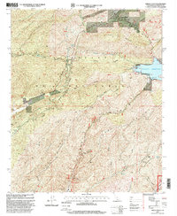
1995 Map of Green Valley
USGS Topo · Published 1999About this map
Green Valley occupies a central position in this study of the northern reaches of the Angeles National Forest, where steep canyon walls and deep ravines define the landscape's utility. The dominance of water management and electrical infrastructure is evident through the massive Bouquet Reservoir, its associated Bouquet Canyon Dam, and the San Francisquito Powerhouse No 1. These features, alongside the Texas Canyon Engineering Work Center, reflect the intensive mid-century engineering required to support the region's growing utility needs.
Find a feature on this map
52 named features on this map. Tap any name to fly to it.
Don’t see what you’re looking for? This feature index may not catch every label — zoom into the map to look around manually.
Map Details
Editions of this 1995 Green Valley Map
This is the sole edition of this map. No revisions or reprints were ever made.
Other maps of this area

1900 · Fernando
USGS Topo · 1:62,500

1901 · Southern California Sheet No. 1
USGS Topo · 1:250,000

1903 · Tejon
USGS Topo · 1:125,000

1903 · Camulos
USGS Topo · 1:125,000

1903 · Santa Susana
USGS Topo · 1:62,500

1904 · Southern California Sheet No. 1
USGS Topo · 1:250,000

1915 · Elizabeth Lake
USGS Topo · 1:125,000

1917 · Elizabeth Lake
USGS Topo · 1:125,000

1929 · Saugus
USGS Topo · 1:24,000

1929 · Lang
USGS Topo · 1:24,000