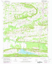
1961 Map of Greenbrier
USGS Topo · Published 1982About this map
Greenbrier and the surrounding Faulkner County countryside are defined by the winding course of the East Fork Cadron Creek and the prominent arc of Horseshoe Mountain. This 1961 survey, updated in the early 1980s, captures a transition from traditional agricultural life to recreational development, most notably visible at Beaver Fork Lake and its dedicated Picnic Point. Genealogists will find a wealth of local landmarks, from rural congregations at Bethlehem Ch and Mountain Grove Ch to family burial grounds like the Estep Cem. Small settlements and road junctions like Wooster, Springhill, and Pleasant Valley anchor the landscape, while the topography of Springfellor Hill and Kaney Ridge dictates the layout of local farms and secondary roads. The map also documents light industrial activity through various Shale Pits and a Quarry near the creek forks.
Find a feature on this map
44 named features on this map. Tap any name to fly to it.
Don’t see what you’re looking for? This feature index may not catch every label — zoom into the map to look around manually.
Map Details
Editions of this 1961 Greenbrier Map
2 editions found
Other maps of this area

1892 · Morrillton
USGS Topo · 1:125,000

1894 · Morrillton
USGS Topo · 1:125,000

1956 · Russellville
USGS Topo · 1:250,000

1961 · Menifee
USGS Topo · 1:24,000

1961 · Gleason
USGS Topo · 1:24,000

1961 · Conway
USGS Topo · 1:24,000

1961 · Conway
USGS Topo · 1:62,500

1961 · Bee Branch
USGS Topo · 1:62,500

1961 · Greenbrier
USGS Topo · 1:24,000

1961 · Damascus
USGS Topo · 1:24,000