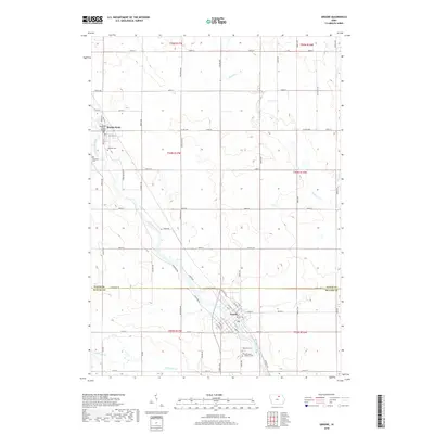
2018 Map of Greene
USGS Topo · Published 2018About this map
Greene and Marble Rock serve as the primary hubs along the Shell Rock River in this 2018 survey of the border between Butler and Floyd counties. The landscape is defined by the winding river valley and its tributaries, including Flood Cr and Coldwater Cr, which cut through a grid of rural section roads. For researchers, the map provides precise locations for several local burial grounds, including Rose Hill Cem and Saint Marys Catholic Cem on the southern edge of Greene, and Hillside Cem near Marble Rock. The town of Greene displays a developed street plan with names like Ely St and Highland Dr, while the Bradford Street Bridge marks a specific crossing point in Marble Rock. The map reveals the continued importance of these riverside communities and their well-preserved cemetery records within the larger agricultural township structure.
Find a feature on this map
53 named features on this map. Tap any name to fly to it.
Don’t see what you’re looking for? This feature index may not catch every label — zoom into the map to look around manually.
Map Details
Editions of this 2018 Greene Map
This is the sole edition of this map. No revisions or reprints were ever made.
Other maps of this area

1954 · Mason City
USGS Topo · 1:250,000

1954 · Waterloo
USGS Topo · 1:250,000

1955 · Waterloo
USGS Topo · 1:250,000

1957 · Mason City
USGS Topo · 1:250,000

1958 · Mason City
USGS Topo · 1:250,000

1971 · Rockford
USGS Topo · 1:24,000

1971 · Charles City
USGS Topo · 1:24,000

1971 · Nashua NW
USGS Topo · 1:24,000

1971 · Clarksville
USGS Topo · 1:24,000
1971 · Roseville
USGS Topo · 1:24,000