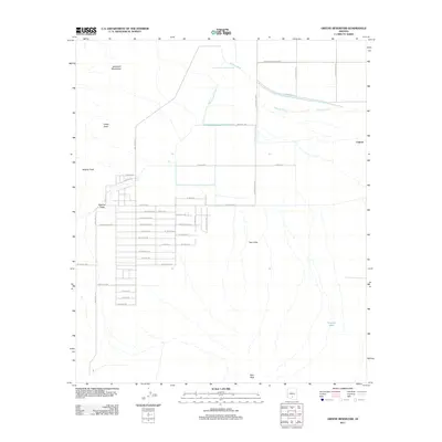
2011 Map of Greene Reservoir
USGS Topo · Published 2011About this map
The Sawtooth Mountains and Indian Head define the western horizon of this Pinal County landscape, which transitions from high desert peaks into the agricultural and residential grids of the Aguirre Valley. In the north, the footprint of the Greene Reservoir (historical) and the course of the Greene Canal illustrate the vital role of water management in this arid environment, alongside the natural drainage of Greene Wash. The map documents a unique residential pattern in the southwest, where a large-scale subdivision features street names inspired by the cosmos, including W Galaxy Dr, W Zodiac Dr, and W Moon Child Ave. To the east, the settlement of Laguna sits near the base of the Tator Hills, while isolated water sources like Porvenir Tank reflect the area's continued reliance on managed resources.
Find a feature on this map
45 named features on this map. Tap any name to fly to it.
Don’t see what you’re looking for? This feature index may not catch every label — zoom into the map to look around manually.
Map Details
Editions of this 2011 Greene Reservoir Map
This is the sole edition of this map. No revisions or reprints were ever made.
Other maps of this area

1934 · Silver Bell
USGS Topo · 1:125,000

1942 · Silver Reef Mountains
USGS Topo · 1:62,500

1947 · Eloy
USGS Topo · 1:62,500

1948 · Eloy
USGS Topo · 1:62,500

1956 · Tucson
USGS Topo · 1:250,000

1958 · Tucson
USGS Topo · 1:250,000

1959 · Tucson
USGS Topo · 1:250,000

1959 · Vaca Hills
USGS Topo · 1:62,500

1962 · Tucson
USGS Topo · 1:250,000
1963 · Santa Rosa Mountains
USGS Topo · 1:62,500