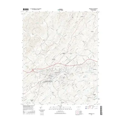
2016 Map of Greeneville
USGS Topo · Published 2016About this map
Greeneville serves as the focal point of this Greene County landscape, anchored by the significant presidential heritage at the Andrew Johnson National Historic Site and the Andrew Johnson National Cemetery. The town's historical depth is reflected in a dense concentration of civic and religious landmarks, including Tusculum College to the east and numerous burial grounds such as Oak Grove Cemetery and Harmony Cemetery. Beyond the urban center, the terrain transitions into a series of named ridges and hollows, including Jones Ridge and Big Hollow, while the Nolichucky River defines the southern boundary near Alexanders Shoals. The intricate road network, featuring names like Gass Memorial Road and Snapps Ferry Road, connects outlying communities such as Tusculum, Fairview, and Sunnyside, tracing a settlement pattern that balances institutional history with the geography of the Appalachian foothills.
Find a feature on this map
247 named features on this map. Tap any name to fly to it.
Don’t see what you’re looking for? This feature index may not catch every label — zoom into the map to look around manually.
Map Details
Editions of this 2016 Greeneville Map
This is the sole edition of this map. No revisions or reprints were ever made.
Other maps of this area

1892 · Greeneville
USGS Topo · 1:125,000

1896 · Greeneville
USGS Topo · 1:125,000

1904 · Greeneville
USGS Topo · 1:125,000

1935 · Surgoinsville
USGS Topo · 1:48,000

1935 · Baileyton
USGS Topo · 1:24,000

1935 · McCloud
USGS Topo · 1:24,000

1935 · Mosheim
USGS Topo · 1:24,000

1935 · Cedar Creek
USGS Topo · 1:24,000

1935 · Fall Branch
USGS Topo · 1:48,000
1935 · Jearoldstown
USGS Topo · 1:24,000