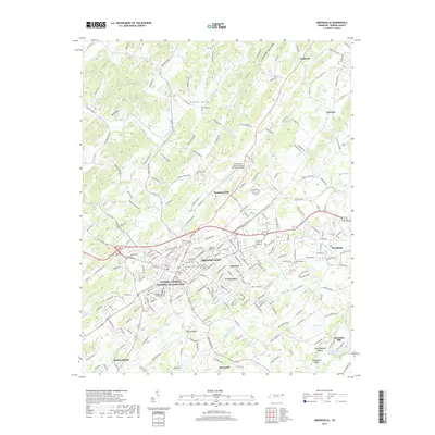
2019 Map of Greeneville
USGS Topo · Published 2019About this map
Greeneville serves as the focal point of this Greene County landscape, anchored by the Andrew Johnson National Historic Site and the adjacent Andrew Johnson National Cem. The town's grid expands into residential developments like Town Acres and Eastview, while to the east, the campus of Tusculum College marks the separate community of Tusculum. This area maintains a high density of small-scale cemeteries, including Harmony Cem and Mount Bethel Cem, which are vital for genealogical research in this part of East Tennessee.
Find a feature on this map
237 named features on this map. Tap any name to fly to it.
Don’t see what you’re looking for? This feature index may not catch every label — zoom into the map to look around manually.
Map Details
Editions of this 2019 Greeneville Map
This is the sole edition of this map. No revisions or reprints were ever made.
Other maps of this area

1892 · Greeneville
USGS Topo · 1:125,000

1896 · Greeneville
USGS Topo · 1:125,000

1904 · Greeneville
USGS Topo · 1:125,000

1935 · Surgoinsville
USGS Topo · 1:48,000

1935 · Baileyton
USGS Topo · 1:24,000

1935 · McCloud
USGS Topo · 1:24,000

1935 · Mosheim
USGS Topo · 1:24,000

1935 · Cedar Creek
USGS Topo · 1:24,000

1935 · Fall Branch
USGS Topo · 1:48,000
1935 · Jearoldstown
USGS Topo · 1:24,000