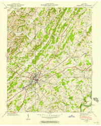
1939 Map of Greeneville
USGS Topo · Published 1958About this map
Greeneville serves as the regional hub of this 1939 Tennessee Valley Authority survey, defined by its intersection of the Southern railroad and the Andrew Johnson Highway. The landscape is a network of small agricultural settlements and family-named landmarks, ranging from Stanton Mill in the southwest to the historic campus of Tusculum College to the east. The terrain is deeply corrugated by waterways like Richland Creek and Roaring Fork, which dictated the placement of early infrastructure like the Gass Bridge Sch and Bale Chapel. A prominent focal point for local history is the Andrew Johnson National Cem, situated just south of the main town center. The map captures the area before modern interstate development, showing a patchwork of rural schools such as Frazier Sch and New Hope Sch that once anchored these East Tennessee communities.
Find a feature on this map
47 named features on this map. Tap any name to fly to it.
Don’t see what you’re looking for? This feature index may not catch every label — zoom into the map to look around manually.
Map Details
Editions of this 1939 Greeneville Map
This is the sole edition of this map. No revisions or reprints were ever made.
Other maps of this area

1892 · Greeneville
USGS Topo · 1:125,000

1896 · Greeneville
USGS Topo · 1:125,000

1904 · Greeneville
USGS Topo · 1:125,000

1935 · Surgoinsville
USGS Topo · 1:48,000

1935 · Baileyton
USGS Topo · 1:24,000

1935 · McCloud
USGS Topo · 1:24,000

1935 · Mosheim
USGS Topo · 1:24,000

1935 · Cedar Creek
USGS Topo · 1:24,000

1935 · Fall Branch
USGS Topo · 1:48,000
1935 · Jearoldstown
USGS Topo · 1:24,000