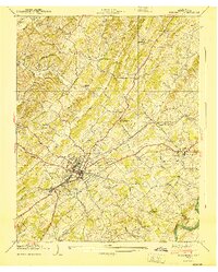
1940 Map of Greeneville
USGS Topo · Published 1940About this map
The town of Greeneville serves as the focal point of this 1940 survey, which captures the community at a crossroads of industry and heritage. The Southern railroad line and major thoroughfares like the Andrew Johnson Highway and John Sevier Highway converge in the town center, illustrating its role as a regional hub. Significant historical sites are clearly marked, including the Andrew Johnson National Monument and the Andrew Johnson National Cem, alongside institutional landmarks like Tusculum College.
Find a feature on this map
79 named features on this map. Tap any name to fly to it.
Don’t see what you’re looking for? This feature index may not catch every label — zoom into the map to look around manually.
Map Details
Editions of this 1940 Greeneville Map
This is the sole edition of this map. No revisions or reprints were ever made.
Other maps of this area

1892 · Greeneville
USGS Topo · 1:125,000

1896 · Greeneville
USGS Topo · 1:125,000

1904 · Greeneville
USGS Topo · 1:125,000

1935 · Surgoinsville
USGS Topo · 1:48,000

1935 · Baileyton
USGS Topo · 1:24,000

1935 · McCloud
USGS Topo · 1:24,000

1935 · Mosheim
USGS Topo · 1:24,000

1935 · Cedar Creek
USGS Topo · 1:24,000

1935 · Fall Branch
USGS Topo · 1:48,000
1935 · Jearoldstown
USGS Topo · 1:24,000