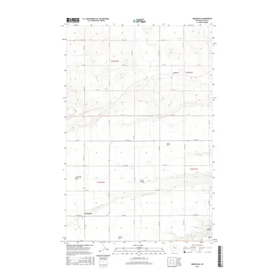
2017 Map of Greenfield
USGS Topo · Published 2017About this map
The settlement of Greenfield and the nearby locale of Cordova anchor this agricultural region in Teton County, where the landscape is defined by a series of distinct geographic elevations. These terraces, labeled as First Bench, Second Bench, and Third Bench, illustrate the stepped topography of the Montana plains. The reliance on managed water systems is evident through the extensive reach of the Greenfields Main Canal, which cuts across the southern portion of the quadrangle, supported by local infrastructure like the Thompson Drain and Plummer Lateral. This network of canals and drains is essential for the farms situated on Greenfields Bench, showing how the land has been engineered to support production. Natural features such as Spring Coulee and Cascade Coulee provide the primary relief in an otherwise strictly surveyed grid of section roads, ranging from 1st Rd NE to 9th Rd NE.
Find a feature on this map
25 named features on this map. Tap any name to fly to it.
Don’t see what you’re looking for? This feature index may not catch every label — zoom into the map to look around manually.
Map Details
Editions of this 2017 Greenfield Map
This is the sole edition of this map. No revisions or reprints were ever made.
Other maps of this area
1886 · Great Falls
USGS Topo · 1:250,000
1949 · Vaughn
USGS Topo · 1:62,500
1950 · Fairfield
USGS Topo · 1:62,500
1950 · Dutton
USGS Topo · 1:62,500
1950 · Collins
USGS Topo · 1:62,500
1952 · Vaughn
USGS Topo · 1:62,500
1954 · Great Falls
USGS Topo · 1:250,000
1957 · Great Falls
USGS Topo · 1:250,000
1976 · Great Falls North
USGS Topo · 1:100,000
1983 · Fort Shaw
USGS Topo · 1:24,000