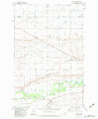
1983 Map of Fort Shaw
USGS Topo · Published 1983About this map
The Fort Shaw Military Reservation Boundary anchors this landscape in north-central Montana, where the legacy of late 19th-century frontier defense meets a complex modern irrigation network. The transition between the high plateaus of First Bench and Second Bench is defined by a dense system of gravity-fed waterworks, including the Greenfields Canal, South Canal, and the Sun River Valley Ditch. These engineering features reflect the transformation of the arid Sun River valley into productive agricultural land.
Find a feature on this map
34 named features on this map. Tap any name to fly to it.
Don’t see what you’re looking for? This feature index may not catch every label — zoom into the map to look around manually.
Map Details
Editions of this 1983 Fort Shaw Map
This is the sole edition of this map. No revisions or reprints were ever made.
Other maps of this area

1886 · Great Falls
USGS Topo · 1:250,000

1949 · Cascade
USGS Topo · 1:62,500

1949 · Vaughn
USGS Topo · 1:62,500

1950 · Fairfield
USGS Topo · 1:62,500

1951 · Cascade
USGS Topo · 1:62,500

1952 · Vaughn
USGS Topo · 1:62,500

1954 · Great Falls
USGS Topo · 1:250,000

1957 · Great Falls
USGS Topo · 1:250,000

1960 · Simms
USGS Topo · 1:62,500

1976 · Great Falls North
USGS Topo · 1:100,000