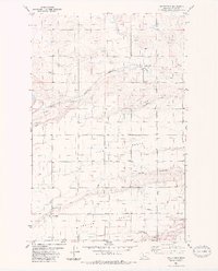
1983 Map of Greenfield
USGS Topo · Published 1983About this map
Irrigation infrastructure and precise grid-based road planning define this portion of Teton County, where the Main Canal and a complex series of lateral drains support the agricultural landscape. The small settlement of Greenfield sits at the southwestern edge of the sheet, connected to the wider region by the Burlington Northern railroad, which follows the winding course of Muddy Creek. To the northeast, the location of Cordova appears along the same rail line, illustrating the importance of transport for these high-plains communities.
Find a feature on this map
21 named features on this map. Tap any name to fly to it.
Don’t see what you’re looking for? This feature index may not catch every label — zoom into the map to look around manually.
Map Details
Editions of this 1983 Greenfield Map
This is the sole edition of this map. No revisions or reprints were ever made.
Other maps of this area

1886 · Great Falls
USGS Topo · 1:250,000

1949 · Vaughn
USGS Topo · 1:62,500

1950 · Fairfield
USGS Topo · 1:62,500

1950 · Dutton
USGS Topo · 1:62,500

1950 · Collins
USGS Topo · 1:62,500

1952 · Vaughn
USGS Topo · 1:62,500

1954 · Great Falls
USGS Topo · 1:250,000

1957 · Great Falls
USGS Topo · 1:250,000

1976 · Great Falls North
USGS Topo · 1:100,000
1983 · Fort Shaw
USGS Topo · 1:24,000