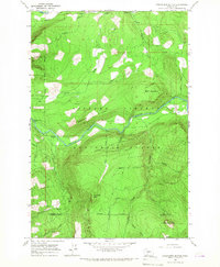
1965 Map of Greenhorn Buttes
USGS Topo · Published 1967About this map
The Cispus River carves through the heart of the Gifford Pinchot National Forest in this mid-1960s topographic study. The landscape is defined by its dramatic relief, where Kraus Ridge and Bluff Mountain overlook the river valley. Evidence of human infrastructure in this remote timber and recreation area is sparse, concentrated primarily along the water and forest access points. Notable landmarks include the Huffaker Bridge and the nearby Iron Creek Campground, while the north is bounded by the Cowlitz River and Skinner Road. To the south, the terrain rises toward the namesake Greenhorn Buttes and Iron Creek Butte. This map captures a specific era of forest management and early recreational development, documenting the Pack Trail and Jeep Trail networks that provided access through the dense drainage basins of Nash Creek and Greenhorn Creek.
Find a feature on this map
32 named features on this map. Tap any name to fly to it.
Don’t see what you’re looking for? This feature index may not catch every label — zoom into the map to look around manually.
Map Details
Editions of this 1965 Greenhorn Buttes Map
This is the sole edition of this map. No revisions or reprints were ever made.
Other maps of this area

1919 · Mount St Helens
USGS Topo · 1:125,000

1924 · Mt Rainier
USGS Topo · 1:96,000

1926 · Steamboat Mtn
USGS Topo · 1:125,000

1928 · Mt Rainier
USGS Topo · 1:125,000
1931 · Steamboat Mtn
USGS Topo · 1:125,000

1937 · Eatonville
USGS Topo · 1:125,000

1950 · Yakima
USGS Topo · 1:250,000

1953 · Hoquiam
USGS Topo · 1:250,000
1956 · Mineral
USGS Topo · 1:62,500

1957 · Hoquiam
USGS Topo · 1:250,000