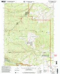
2001 Map of Greenie Mountain
USGS Topo · Published 2005About this map
Rio Grande National Forest dominates this section of the San Juan Mountains, where the high-altitude terrain is carved by the Alamosa River and numerous drainages like Cat Creek and Rock Creek. This 2001 revision highlights a landscape managed for both preservation and utility, featuring the Rock Creek Recreational Area alongside scattered industrial markers such as a Mine and Prospect near Poison Gulch. The map identifies localized centers of activity like Camp Val Verde, Lost Cabin Ranch, and the Phillips University Camp situated near the riverbanks. Administrative boundaries are clearly marked, including the Rio Grande Co Conejos Co line and the Silver Ninth Standard Parallel North, which provides a glimpse into the formal surveying structure used to parcel this mountain territory. Notable landmarks such as Greenie Mountain and Lion Point anchor the topography, while the Rock Creek Trail and Comstock Trail trace historic routes through the gulches.
Find a feature on this map
44 named features on this map. Tap any name to fly to it.
Don’t see what you’re looking for? This feature index may not catch every label — zoom into the map to look around manually.
Map Details
Editions of this 2001 Greenie Mountain Map
This is the sole edition of this map. No revisions or reprints were ever made.
Other maps of this area

1915 · Del Norte
USGS Topo · 1:125,000

1917 · Del Norte
USGS Topo · 1:125,000

1922 · Conejos
USGS Topo · 1:125,000

1945 · Durango
USGS Topo · 1:250,000

1953 · Durango
USGS Topo · 1:250,000

1954 · Durango
USGS Topo · 1:250,000

1961 · Durango
USGS Topo · 1:250,000

1963 · Durango
USGS Topo · 1:250,000

1964 · Monte Vista
USGS Topo · 1:24,000

1966 · Durango
USGS Topo · 1:250,000