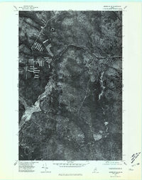
1975 Map of Greenlaw SE
USGS Topo · Published 1981About this map
The Machias River meanders through this undeveloped stretch of the Maine woods, reflecting the landscape as it appeared in the mid-1970s. This orthophotoquad provides an unfiltered view of the timberland, where the intricate drainage patterns of Greenlaw Stream and Carry Brook define the topography. The lack of traditional settlement labels highlights the commercial timber harvesting operations of the era, visible in the distinct clearing patterns and logging roads that cut through the dense forest canopy. Near the confluence of the South Branch, the winding river channels suggest a riparian environment that has remained largely unchanged by permanent residential development, preserving a specific moment in the industrial forestry history of the North Maine Woods.
Find a feature on this map
4 named features on this map. Tap any name to fly to it.
Don’t see what you’re looking for? This feature index may not catch every label — zoom into the map to look around manually.
Map Details
Editions of this 1975 Greenlaw SE Map
This is the sole edition of this map. No revisions or reprints were ever made.
Other maps of this area

1930 · Greenlaw
USGS Topo · 1:48,000

1931 · Ashland
USGS Topo · 1:48,000

1933 · Greenlaw
USGS Topo · 1:62,500

1934 · Ashland
USGS Topo · 1:62,500

1940 · Oxbow
USGS Topo · 1:62,500

1942 · Oxbow
USGS Topo · 1:62,500

1953 · Ashland
USGS Topo · 1:62,500

1954 · Grand Lake Seboeis
USGS Topo · 1:62,500

1954 · Presque Isle
USGS Topo · 1:250,000

1958 · Presque Isle
USGS Topo · 1:250,000