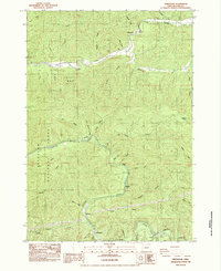
1984 Map of Greenleaf
USGS Topo · Published 1984About this map
The Siuslaw River snakes through the heart of the Coast Range in this 1984 survey, defining a landscape shaped by timber and transport. Small settlements like Greenleaf and Nelson sit along the winding Siuslaw Highway, while the Southern Pacific railroad parallels the river's southern banks near Austa and Linslaw. This era of the mid-1980s shows the region's transition, documenting the Beecher (Site) and a legacy of rural education at the School House near Richardson. The map's heavy contour lines reflect the steep drainage basins of Lake Creek and Wildcat Creek, which feed into the main river system. Within the Siuslaw National Forest, topographic details highlight ridges like Bailey Ridge and Barber Ridge, alongside local industrial marks such as a Quarry near Lake Creek.
Find a feature on this map
45 named features on this map. Tap any name to fly to it.
Don’t see what you’re looking for? This feature index may not catch every label — zoom into the map to look around manually.
Map Details
Editions of this 1984 Greenleaf Map
This is the sole edition of this map. No revisions or reprints were ever made.
Other maps of this area

1918 · Mapleton
USGS Topo · 1:48,000

1919 · Earl
USGS Topo · 1:48,000

1940 · Mapleton
USGS Topo · 1:62,500

1941 · Blachly
USGS Topo · 1:62,500

1942 · Blachly
USGS Topo · 1:62,500

1942 · Roman Nose Mtn
USGS Topo · 1:62,500

1943 · Goodwin Peak
USGS Topo · 1:62,500

1945 · Mapleton
USGS Topo · 1:62,500

1945 · Roman Nose Mtn
USGS Topo · 1:62,500

1953 · Salem
USGS Topo · 1:250,000