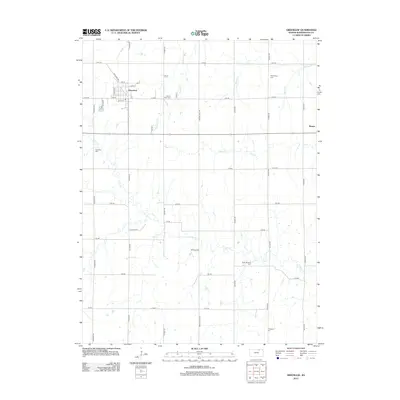
2012 Map of Greenleaf
USGS Topo · Published 2012About this map
Greenleaf anchors this section of Washington County, showing a classic Midwestern grid with streets like Railroad Ave and Locust St reflecting its historical layout. To the east, the smaller settlement of Barnes sits along a primary east-west corridor, surrounded by a landscape carved by winding waterways such as Coon Cr and Beaver Cr. This 2012 survey captures a rural landscape where local heritage is preserved in numerous burial grounds, including Sacred Heart Cem near the town center and more isolated sites like Saint Boniface Cem and Chepstow Cem further south. The land is strictly partitioned by a network of rural roads including Wagon Train Rd and Yankee Rd, illustrating the enduring township and range survey system that continues to define Kansas agriculture and property lines.
Find a feature on this map
39 named features on this map. Tap any name to fly to it.
Don’t see what you’re looking for? This feature index may not catch every label — zoom into the map to look around manually.
Map Details
Editions of this 2012 Greenleaf Map
This is the sole edition of this map. No revisions or reprints were ever made.
Other maps of this area

1889 · Marysville
USGS Topo · 1:125,000

1893 · Washington
USGS Topo · 1:125,000

1894 · Marysville
USGS Topo · 1:125,000

1955 · Manhattan
USGS Topo · 1:250,000

1956 · Manhattan
USGS Topo · 1:250,000

1957 · Manhattan
USGS Topo · 1:250,000

1966 · Washington
USGS Topo · 1:24,000

1966 · Hanover SE
USGS Topo · 1:24,000

1966 · Hanover SW
USGS Topo · 1:24,000
1968 · Linn
USGS Topo · 1:24,000