
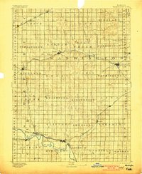
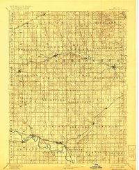
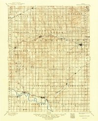
1893 Map of Washington
USGS Topo · Published 1893About this map
Republican River valley life in the late nineteenth century is defined by a dense web of competing railroads serving isolated agricultural townships. This survey, conducted by R.M. Towson and H.L. Baldwin Jr., captures the region as several major rail lines, including the Chicago Rock Island and Pacific Railway and the Missouri Pacific Railroad, reached their peak influence over local commerce. The settlement of Washington stands as a primary hub, while smaller outposts like Brantford and Haddam anchor the surrounding gridded sections. The landscape is carved by numerous waterways such as Mill Creek and Parsons Creek, which dictated the early layout of roads and rail crossings. Genealogists will find interest in the clear delineation of civil townships, such as Strawberry and Mulberry, providing a precise geographic context for family records before the turn of the century.
Find a feature on this map
71 named features on this map. Tap any name to fly to it.
Don’t see what you’re looking for? This feature index may not catch every label — zoom into the map to look around manually.
Map Details
Editions of this 1893 Washington Map
4 editions found
Other maps of this area

1886 · Junction City
USGS Topo · 1:125,000

1889 · Marysville
USGS Topo · 1:125,000

1889 · Junction City
USGS Topo · 1:125,000

1891 · Clay Center
USGS Topo · 1:125,000

1892 · Concordia
USGS Topo · 1:125,000

1892 · Minneapolis
USGS Topo · 1:125,000

1894 · Junction City
USGS Topo · 1:125,000

1894 · Marysville
USGS Topo · 1:125,000

1898 · Hebron
USGS Topo · 1:125,000

1955 · Manhattan
USGS Topo · 1:250,000