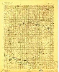
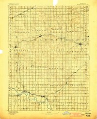
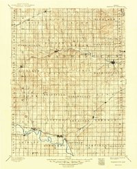
1893 Map of Washington
USGS Topo · Published 1921About this map
The Republican River winds through the southwestern corner of this Kansas landscape, serving as a vital corridor for early settlement and transport near Clyde and Clifton. Surveyed in the late nineteenth century, the map documents a region defined by its emerging rail network, featuring the Chicago Rock Island and Pacific Railway and the Union Pacific Railway. These lines facilitated the growth of rural hubs such as Washington, Haddam, and Linn. Beyond the rail towns, the land is divided into numerous named townships like Strawberry and Brantford, reflecting the organized expansion of agriculture across the plains. Tributaries such as Mill Creek and Parsons Creek carve through the topography, illustrating the drainage patterns that dictated early farmstead placement and townsite selection before the turn of the century.
Find a feature on this map
63 named features on this map. Tap any name to fly to it.
Don’t see what you’re looking for? This feature index may not catch every label — zoom into the map to look around manually.
Map Details
Editions of this 1893 Washington Map
4 editions found
Other maps of this area

1886 · Junction City
USGS Topo · 1:125,000

1889 · Marysville
USGS Topo · 1:125,000

1889 · Junction City
USGS Topo · 1:125,000

1891 · Clay Center
USGS Topo · 1:125,000

1892 · Concordia
USGS Topo · 1:125,000

1892 · Minneapolis
USGS Topo · 1:125,000

1893 · Washington
USGS Topo · 1:125,000

1894 · Junction City
USGS Topo · 1:125,000

1894 · Marysville
USGS Topo · 1:125,000

1898 · Hebron
USGS Topo · 1:125,000