
1892 Map of Minneapolis
USGS Topo · Published 1892About this map
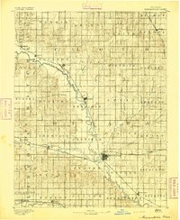
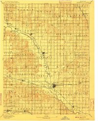
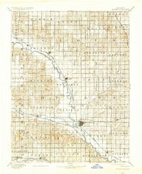
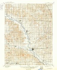
Minneapolis stands as a central hub in this late nineteenth-century portrait of North Central Kansas, where the Solomon River carves a fertile valley across the prairie. The landscape is defined by the organized township structure of Cloud and Ottawa counties, with the river serving as a primary corridor for settlement and transit. Early rail development is evident as the Atchison Topeka and Santa Fe Railroad and the Union Pacific Railway begin to integrate small agricultural communities like Delphos, Glasco, and Bennington into the national economy. To the south, the Saline River cuts across the corner of the sheet near Beverly and Tescott. The map documents numerous creeks, including Pipe Creek and Asher Creek, which supported the early farms and homesteads of the 1890s, revealing the precise hydrology that determined the location of towns such as Asherville and Ada.
Find a feature on this map
59 named features on this map. Tap any name to fly to it.
Don’t see what you’re looking for? This feature index may not catch every label — zoom into the map to look around manually.
Map Details
Editions of this 1892 Minneapolis Map
5 editions found
Historical Maps of Minneapolis Through Time
1 maps found