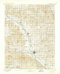
1892 Map of Minneapolis
USGS Topo · Published 1937About this map
The Solomon River defines the path of commerce and settlement across this central Kansas landscape, winding southeastward past the growing rail hubs of Glasco, Delphos, and Minneapolis. Surveyed in the late nineteenth century, the map reveals a transition from open prairie to an organized grid of townships, where the Atchison Topeka and Santa Fe Railroad and the Union Pacific Railway dictate the placement of rural stations and grain stops. Smaller communities such as Ada and Wells appear as modest outposts along the secondary drainages of Salt Creek and Pipe Creek. To the south, the Saline River cuts through the territory near Beverly and Tescott, anchoring the agricultural development of the region during a period of rapid westward expansion and iron-rail dominance.
Find a feature on this map
54 named features on this map. Tap any name to fly to it.
Don’t see what you’re looking for? This feature index may not catch every label — zoom into the map to look around manually.
Map Details
Editions of this 1892 Minneapolis Map
5 editions found
Other maps of this area

1889 · Abilene
USGS Topo · 1:125,000

1891 · Clay Center
USGS Topo · 1:125,000

1892 · Concordia
USGS Topo · 1:125,000

1892 · Salina
USGS Topo · 1:125,000

1892 · Minneapolis
USGS Topo · 1:125,000

1893 · Washington
USGS Topo · 1:125,000

1894 · Ellsworth
USGS Topo · 1:125,000

1894 · Abilene
USGS Topo · 1:125,000

1894 · Mankato
USGS Topo · 1:125,000

1894 · Beloit
USGS Topo · 1:125,000