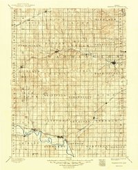
1893 Map of Washington
USGS Topo · Published 1949About this map
The Republican River meanders through the southern portion of this region, providing a natural anchor for the frontier settlements of Clyde, Vining, and Clifton. Surveyed in the 1890s, the landscape is defined by the rapid expansion of rail networks that connected these agricultural hubs to the wider world. Five distinct lines, including the Chicago Rock Island and Pacific Railway and the Union Pacific Railway, crisscross the terrain, often dictating the placement of small towns like Haddam, Linn, and Narka at key junctions.
Find a feature on this map
71 named features on this map. Tap any name to fly to it.
Don’t see what you’re looking for? This feature index may not catch every label — zoom into the map to look around manually.
Map Details
Editions of this 1893 Washington Map
4 editions found
Other maps of this area

1886 · Junction City
USGS Topo · 1:125,000

1889 · Marysville
USGS Topo · 1:125,000

1889 · Junction City
USGS Topo · 1:125,000

1891 · Clay Center
USGS Topo · 1:125,000

1892 · Concordia
USGS Topo · 1:125,000

1892 · Minneapolis
USGS Topo · 1:125,000

1893 · Washington
USGS Topo · 1:125,000

1894 · Junction City
USGS Topo · 1:125,000

1894 · Marysville
USGS Topo · 1:125,000

1898 · Hebron
USGS Topo · 1:125,000