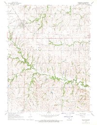
1968 Map of Greenleaf
USGS Topo · Published 1969About this map
The Missouri Pacific railroad corridor anchors this late-1960s survey of eastern Washington County, tracing a path through the grain-growing uplands between the Little Blue River and Coon Creek. The town of Greenleaf stands as the primary hub, surrounded by a landscape dotted with the spiritual and ancestral markers of the community's early settlers. Numerous rural burial grounds, such as Maplewood Cem, St Boniface Cem, and Chepstow Cem, are scattered across the townships of Logan, Greenleaf, and Lincoln, providing essential data points for genealogists. The presence of Sacred Heart Ch and its accompanying Sacred Heart Cem highlights the enduring religious centers that shaped local identity in this part of the Kansas prairie. Further east, the small settlement of Barnes sits along the rail line, while the nearly vanished location of Malone remains marked near the northern boundary.
Find a feature on this map
16 named features on this map. Tap any name to fly to it.
Don’t see what you’re looking for? This feature index may not catch every label — zoom into the map to look around manually.
Map Details
Editions of this 1968 Greenleaf Map
2 editions found
Other maps of this area

1889 · Marysville
USGS Topo · 1:125,000

1893 · Washington
USGS Topo · 1:125,000

1894 · Marysville
USGS Topo · 1:125,000

1955 · Manhattan
USGS Topo · 1:250,000

1956 · Manhattan
USGS Topo · 1:250,000

1957 · Manhattan
USGS Topo · 1:250,000

1966 · Washington
USGS Topo · 1:24,000

1966 · Hanover SE
USGS Topo · 1:24,000

1966 · Hanover SW
USGS Topo · 1:24,000
1968 · Linn
USGS Topo · 1:24,000