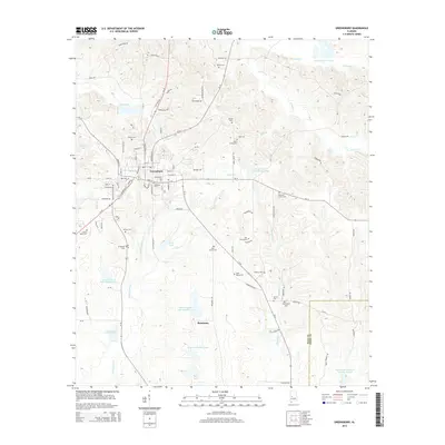
2014 Map of Greensboro
USGS Topo · Published 2014About this map
Greensboro serves as the focal point of this Black Belt landscape, where the town’s established grid gives way to a network of rural roads and family-named cemeteries. The area is defined by a dense concentration of burial grounds such as Oakwood Cem, Greensboro Cem, and the Jenkins Place Cem, which offer significant value for genealogical research in Hale County. The surrounding terrain is punctuated by numerous managed water bodies, including Gross Lake, Morrison Brothers Lake, and several numbered reservoirs like Lewis Lawson Lake Number Four. To the south, the small community of Rosemary sits near the headwaters of Whitsitt Cr. The drainage patterns of Colwell Cr and Bills Br carve through the landscape, illustrating the traditional rural land divisions that have persisted into the twenty-first century.
Find a feature on this map
90 named features on this map. Tap any name to fly to it.
Don’t see what you’re looking for? This feature index may not catch every label — zoom into the map to look around manually.
Map Details
Editions of this 2014 Greensboro Map
This is the sole edition of this map. No revisions or reprints were ever made.
Other maps of this area

1953 · Montgomery
USGS Topo · 1:250,000

1956 · Montgomery
USGS Topo · 1:250,000

1957 · Montgomery
USGS Topo · 1:250,000

1979 · Scott Station
USGS Topo · 1:24,000

1979 · Morgan Springs
USGS Topo · 1:24,000

1979 · Greensboro
USGS Topo · 1:24,000
1980 · Casemore
USGS Topo · 1:24,000

1980 · Ingram
USGS Topo · 1:24,000
1980 · Newbern
USGS Topo · 1:24,000
1980 · Sawyerville
USGS Topo · 1:24,000