
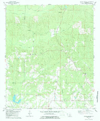
1979 Map of Morgan Springs
USGS Topo · Published 1980About this map
Morgan Springs and Folsom serve as central points in this rural landscape along the boundary of Hale and Perry counties. The area is defined by its numerous small congregational centers and family burial grounds, reflecting a deeply rooted community structure in the late 1970s. Key landmarks such as the Morgan Springs Lookout Tower and a prominent Water Tank punctuate the ridges, while agricultural and extractive activities are noted through several Gravel Pits scattered near the local roads.
Find a feature on this map
27 named features on this map. Tap any name to fly to it.
Don’t see what you’re looking for? This feature index may not catch every label — zoom into the map to look around manually.
Map Details
Editions of this 1979 Morgan Springs Map
2 editions found
Other maps of this area

1953 · Montgomery
USGS Topo · 1:250,000

1956 · Montgomery
USGS Topo · 1:250,000

1957 · Montgomery
USGS Topo · 1:250,000

1979 · Marion North
USGS Topo · 1:24,000

1979 · Scott Station
USGS Topo · 1:24,000

1979 · Marion South
USGS Topo · 1:24,000

1979 · Greensboro
USGS Topo · 1:24,000

1980 · Ingram
USGS Topo · 1:24,000
1980 · Newbern
USGS Topo · 1:24,000
1980 · Hogglesville
USGS Topo · 1:24,000