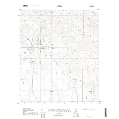
2020 Map of Greensboro
USGS Topo · Published 2020About this map
Greensboro serves as the regional anchor for this part of Alabama, defined by a concentration of civic and social history at the Hale County Courthouse. The town’s layout is deeply documented through its cemeteries, ranging from the central Greensboro Cem and Oakwood Martin Cem to smaller family and community plots such as McCoy Cem and Jenkins Place Cem. This distribution suggests a landscape of long-established landholdings and distinct neighborhoods that spread outward toward the settlement at Rosemary.
Find a feature on this map
102 named features on this map. Tap any name to fly to it.
Don’t see what you’re looking for? This feature index may not catch every label — zoom into the map to look around manually.
Map Details
Editions of this 2020 Greensboro Map
This is the sole edition of this map. No revisions or reprints were ever made.
Other maps of this area

1953 · Montgomery
USGS Topo · 1:250,000

1956 · Montgomery
USGS Topo · 1:250,000

1957 · Montgomery
USGS Topo · 1:250,000

1979 · Scott Station
USGS Topo · 1:24,000

1979 · Morgan Springs
USGS Topo · 1:24,000

1979 · Greensboro
USGS Topo · 1:24,000
1980 · Casemore
USGS Topo · 1:24,000

1980 · Ingram
USGS Topo · 1:24,000
1980 · Newbern
USGS Topo · 1:24,000
1980 · Sawyerville
USGS Topo · 1:24,000