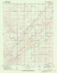
1969 Map of Greensburg NE
USGS Topo · Published 1971About this map
Rattlesnake Creek meanders through this portion of the Kansas High Plains, providing a primary drainage feature for the surrounding agricultural landscape during the late 1960s. The terrain is divided into distinct administrative and geographic blocks such as Butler, Valley, and Center, reflecting the township and range survey system. A significant network of pipelines crisscrosses the map, indicating the area's role in the regional energy infrastructure. This industrial presence is further evidenced by several oil wells, a gas well, and a Compressor Station equipped with a Water Tank. These features, alongside a Radio Tower and various wells, document a specialized landscape where cattle ranching or dryland farming coexists with active petroleum and natural gas extraction. The boundary between Edwards and Kiowa counties runs through the northern section, marking a key jurisdictional line for local researchers.
Find a feature on this map
18 named features on this map. Tap any name to fly to it.
Don’t see what you’re looking for? This feature index may not catch every label — zoom into the map to look around manually.
Map Details
Editions of this 1969 Greensburg NE Map
2 editions found
Other maps of this area

1889 · Kinsley
USGS Topo · 1:125,000

1892 · Kinsley
USGS Topo · 1:125,000

1894 · Kinsley
USGS Topo · 1:125,000

1955 · Pratt
USGS Topo · 1:250,000

1959 · Pratt
USGS Topo · 1:250,000

1968 · Haviland NW
USGS Topo · 1:24,000

1968 · Brenham
USGS Topo · 1:24,000

1969 · Greensburg NW
USGS Topo · 1:24,000
1969 · Greensburg
USGS Topo · 1:24,000
1969 · Mullinville
USGS Topo · 1:24,000