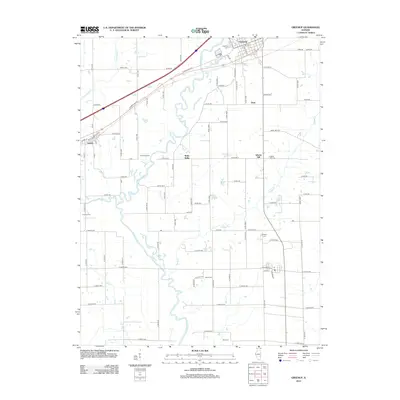
2012 Map of Greenup
USGS Topo · Published 2012About this map
The Embarras River meanders south through this section of Cumberland County, carving a serpentine path through the Illinois landscape between the settlements of Greenup and Jewett. This 2012 survey documents a rural environment structured around historic road networks like Cumberland Rd and York Rd, while preserving several smaller communities such as Walla Walla, Dees, and Liberty Hill. For genealogists and local historians, the map is a primary source for locating family burial grounds, including Greenup Cem, Salem Cem, and Hidalgo Cem. The presence of numerous tributaries like Cottonwood Cr, Muddy Cr, and Range Cr illustrates the complex local drainage system that has influenced agricultural development and property lines in the region for generations.
Find a feature on this map
87 named features on this map. Tap any name to fly to it.
Don’t see what you’re looking for? This feature index may not catch every label — zoom into the map to look around manually.
Map Details
Editions of this 2012 Greenup Map
This is the sole edition of this map. No revisions or reprints were ever made.
Other maps of this area

1933 · Toledo
USGS Topo · 1:62,500

1934 · Mattoon
USGS Topo · 1:62,500

1937 · Mattoon
USGS Topo · 1:62,500

1938 · Toledo
USGS Topo · 1:62,500

1940 · Greenup
USGS Topo · 1:62,500

1943 · Greenup
USGS Topo · 1:62,500

1953 · Teutopolis
USGS Topo · 1:62,500

1958 · Decatur
USGS Topo · 1:250,000

1961 · Decatur
USGS Topo · 1:250,000
1984 · Toledo
USGS Topo · 1:24,000