
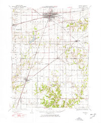
1934 Map of Mattoon
USGS Topo · Published 1967About this map
Mattoon serves as the central hub of this mid-1930s landscape, where the New York Central and Illinois Central railroads intersect in a classic grid-iron city plan. This era shows the region's transition from purely agricultural to more complex water management, notably with the presence of Lake Mattoon and the adjacent State Fish Hatchery. The surrounding townships, including Lafayette and Paradise, are densely populated with small country schools like Little Brick Sch and Mound Sch, marking the rural education infrastructure before mid-century consolidation.
Find a feature on this map
95 named features on this map. Tap any name to fly to it.
Don’t see what you’re looking for? This feature index may not catch every label — zoom into the map to look around manually.
Map Details
Editions of this 1934 Mattoon Map
2 editions found
Other maps of this area

1933 · Toledo
USGS Topo · 1:62,500

1935 · Arcola
USGS Topo · 1:48,000

1935 · Sullivan
USGS Topo · 1:48,000

1936 · Oakland
USGS Topo · 1:48,000

1937 · Mattoon
USGS Topo · 1:62,500

1938 · Toledo
USGS Topo · 1:62,500

1940 · Sullivan
USGS Topo · 1:62,500

1940 · Arcola
USGS Topo · 1:62,500

1940 · Greenup
USGS Topo · 1:62,500

1942 · Oakland
USGS Topo · 1:62,500