
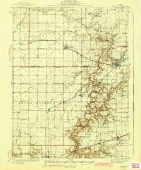
1942 Map of Oakland
USGS Topo · Published 1942About this map
The Embarrass River carves a deep, wooded corridor through the level prairie land of Coles and Douglas Counties, defining the drainage patterns for the surrounding townships of Bowdre, Sargent, and Oakland. In the early 1940s, this region was a dense network of rural school districts and family-named landmarks, reflecting an era of localized agrarian community life. Educational hubs like the Seven Hickory Sch and Winkleblack Sch served the outlying farmsteads, while the Pennsylvania railroad line connected the elevators at Hindsboro, Kemp, and Oakland. Genealogists will find significant value in the documentation of small family burial grounds, such as the Patsy Mitchell Cem and Guinn Cem, which sit alongside established congregations at Oak Grove Ch and Antioch Sch. The map also captures the early civil infrastructure of the day, including the Barnett Bridge crossing and the Brushy Fork Town Hall.
Find a feature on this map
93 named features on this map. Tap any name to fly to it.
Don’t see what you’re looking for? This feature index may not catch every label — zoom into the map to look around manually.
Map Details
Editions of this 1942 Oakland Map
2 editions found
Other maps of this area

1933 · Toledo
USGS Topo · 1:62,500

1934 · Mattoon
USGS Topo · 1:62,500

1935 · Arcola
USGS Topo · 1:48,000

1936 · Oakland
USGS Topo · 1:48,000

1936 · Casey
USGS Topo · 1:48,000

1937 · Mattoon
USGS Topo · 1:62,500

1938 · Toledo
USGS Topo · 1:62,500

1940 · Arcola
USGS Topo · 1:62,500

1942 · Casey
USGS Topo · 1:62,500

1943 · Casey
USGS Topo · 1:62,500