
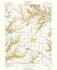
1953 Map of Teutopolis
USGS Topo · Published 1955About this map
Teutopolis and the surrounding agricultural townships of Effingham, Cumberland, and Jasper Counties are captured here during the mid-1950s. The landscape is defined by a dense network of rural infrastructure, where country schools like Butterfly Sch and Spring Point Sch served farming families between larger settlements. The influence of the energy sector is visible through the presence of Oil Wells and Oil Tanks scattered through the northern sections of the quadrangle.
Find a feature on this map
65 named features on this map. Tap any name to fly to it.
Don’t see what you’re looking for? This feature index may not catch every label — zoom into the map to look around manually.
Map Details
Editions of this 1953 Teutopolis Map
2 editions found
Other maps of this area

1933 · Toledo
USGS Topo · 1:62,500

1934 · Mattoon
USGS Topo · 1:62,500

1937 · Mattoon
USGS Topo · 1:62,500

1938 · Toledo
USGS Topo · 1:62,500

1940 · Greenup
USGS Topo · 1:62,500

1941 · Newton
USGS Topo · 1:62,500

1943 · Greenup
USGS Topo · 1:62,500

1943 · Newton
USGS Topo · 1:62,500

1947 · Stewardson
USGS Topo · 1:62,500

1949 · Stewardson
USGS Topo · 1:62,500