
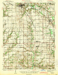
1943 Map of Newton
USGS Topo · Published 1943About this map
The Embarrass River meanders through this agricultural landscape of central Illinois, connecting the commercial hub of Newton with smaller outposts like Ste Marie and West Liberty. The Illinois Central railroad defines the regional transport corridor, passing through Boos and Dundas as it serves the grain-producing heartland. This 1941 survey captures a dense network of early 20th-century rural infrastructure, including dozens of named country schools such as Brush College Sch, Onion Prairie Sch, and Happy Hollow Sch. Genealogists will find significant value in the distribution of family-named landmarks and secluded burial grounds like Rohbaugh Cem and Bethel Cem. The transition from Jasper Co to Richland Co is marked by a shift in terrain toward the Fox River drainage, where small settlements like Passport and Rafetown appear along the sectional section lines.
Find a feature on this map
92 named features on this map. Tap any name to fly to it.
Don’t see what you’re looking for? This feature index may not catch every label — zoom into the map to look around manually.
Map Details
Editions of this 1943 Newton Map
2 editions found
Other maps of this area

1910 · Hardinville
USGS Topo · 1:62,500

1911 · Sumner
USGS Topo · 1:62,500

1913 · Sumner
USGS Topo · 1:62,500

1940 · Greenup
USGS Topo · 1:62,500

1941 · Newton
USGS Topo · 1:62,500

1943 · Greenup
USGS Topo · 1:62,500

1948 · Flora
USGS Topo · 1:62,500

1949 · Olney
USGS Topo · 1:62,500

1949 · Flora
USGS Topo · 1:62,500

1953 · Teutopolis
USGS Topo · 1:62,500