
1949 Map of Olney
USGS Topo · Published 1949About this map
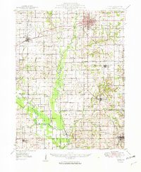
The Baltimore and Ohio RR and Illinois Central railroads anchor the rural economy of Richland and Wayne Counties in this late 1940s study. The settlement of Olney serves as a significant regional hub, characterized by its gridiron streets, while smaller communities like Noble, Parkersburg, and Wynoose are distributed across a landscape defined by the Fox River and Little Wabash River.
Find a feature on this map
94 named features on this map. Tap any name to fly to it.
Don’t see what you’re looking for? This feature index may not catch every label — zoom into the map to look around manually.
Map Details
Editions of this 1949 Olney Map
2 editions found
Other maps of this area

1903 · Patoka
USGS Topo · 1:125,000

1904 · Mount Carmel
USGS Topo · 1:62,500

1910 · Hardinville
USGS Topo · 1:62,500

1911 · Sumner
USGS Topo · 1:62,500

1913 · Sumner
USGS Topo · 1:62,500

1941 · Newton
USGS Topo · 1:62,500

1943 · Newton
USGS Topo · 1:62,500

1943 · Albion
USGS Topo · 1:62,500

1946 · Albion
USGS Topo · 1:62,500

1948 · Fairfield
USGS Topo · 1:62,500