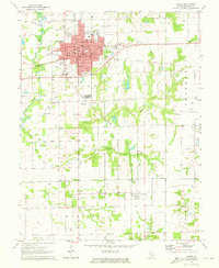
1971 Map of Olney
USGS Topo · Published 1973About this map
Olney serves as the regional hub at the crossing of the Illinois Central and Baltimore and Ohio railroads. This early 1970s landscape is defined by its institutional and industrial infrastructure, ranging from Olney Central College and the Waterworks to a numerous collection of Oil Wells peppered across the surrounding countryside. The town plan is densely packed with local landmarks like Bower Park and the Courthouse, while the outskirts feature mid-century cultural markers such as a Drive-in Theater.
Find a feature on this map
54 named features on this map. Tap any name to fly to it.
Don’t see what you’re looking for? This feature index may not catch every label — zoom into the map to look around manually.
Map Details
Editions of this 1971 Olney Map
2 editions found
Other maps of this area

1910 · Hardinville
USGS Topo · 1:62,500

1911 · Sumner
USGS Topo · 1:62,500

1913 · Sumner
USGS Topo · 1:62,500

1941 · Newton
USGS Topo · 1:62,500

1943 · Newton
USGS Topo · 1:62,500

1949 · Olney
USGS Topo · 1:62,500

1956 · Vincennes
USGS Topo · 1:250,000

1957 · Vincennes
USGS Topo · 1:250,000

1958 · Vincennes
USGS Topo · 1:250,000

1958 · Belleville
USGS Topo · 1:250,000