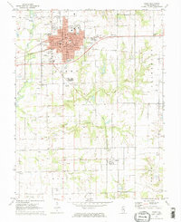
1971 Map of Olney
USGS Topo · Published 1973About this map
Olney serves as the focal point of this Richland County survey, showing a well-established regional hub where the Baltimore and Ohio and Illinois Central railroads intersect. The town's social and educational landscape is marked by the campus of Olney Central College and local institutions like Richland Sch and Cherry Street Sch. Numerous cemeteries, including Haven Hill Cem, St Joseph Cem, and Maple Dale Cem, provide significant data points for local genealogists. Beyond the urban center, the land transitions into a productive landscape dotted with Oil Wells and a scattering of smaller settlements like Calhoun. The hydrology of the region is defined by the Fox River and its tributaries, including Little Fox Creek and Big Creek, which weave through the agricultural and extraction fields of southeastern Illinois.
Find a feature on this map
48 named features on this map. Tap any name to fly to it.
Don’t see what you’re looking for? This feature index may not catch every label — zoom into the map to look around manually.
Map Details
Editions of this 1971 Olney Map
2 editions found
Other maps of this area

1910 · Hardinville
USGS Topo · 1:62,500

1911 · Sumner
USGS Topo · 1:62,500

1913 · Sumner
USGS Topo · 1:62,500

1941 · Newton
USGS Topo · 1:62,500

1943 · Newton
USGS Topo · 1:62,500

1949 · Olney
USGS Topo · 1:62,500

1956 · Vincennes
USGS Topo · 1:250,000

1957 · Vincennes
USGS Topo · 1:250,000

1958 · Vincennes
USGS Topo · 1:250,000

1958 · Belleville
USGS Topo · 1:250,000