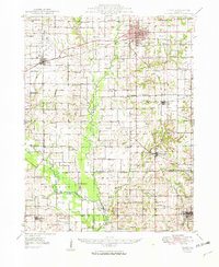
1949 Map of Olney
USGS Topo · Published 1949About this map
Olney serves as the hub of this Richland County landscape, where the Baltimore and Ohio and Illinois Central railroads intersect amidst a dense network of rural schools and churches. The survey captures the region as petroleum exploration began to mark the land, evidenced by several Oil Fields and numerous Oil Wells scattered near Noble and the banks of the Little Wabash River. To the south, the topography rises toward Mount Erie, while the community of Parkersburg anchors the southeastern corner.
Find a feature on this map
94 named features on this map. Tap any name to fly to it.
Don’t see what you’re looking for? This feature index may not catch every label — zoom into the map to look around manually.
Map Details
Editions of this 1949 Olney Map
2 editions found

Other maps of this area

1903 · Patoka
USGS Topo · 1:125,000

1904 · Mount Carmel
USGS Topo · 1:62,500

1910 · Hardinville
USGS Topo · 1:62,500

1911 · Sumner
USGS Topo · 1:62,500

1913 · Sumner
USGS Topo · 1:62,500

1941 · Newton
USGS Topo · 1:62,500

1943 · Newton
USGS Topo · 1:62,500

1943 · Albion
USGS Topo · 1:62,500

1946 · Albion
USGS Topo · 1:62,500

1948 · Fairfield
USGS Topo · 1:62,500