1946 Map of Albion
USGS Topo · Published 1946About this map
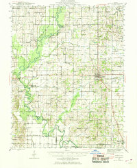
Albion and the surrounding rural townships of Edwards and Wayne Counties are captured here just after the war, showing a landscape defined by small-town hubs and a dense network of country schools. The Southern railroad serves as the primary industrial artery, connecting Golden Gate, Ellery, and Albion to the wider region. In the west, the Little Wabash River meanders through bottomlands marked by numerous oxbow features like Halfmoon Pd and Old River I, spanned by named crossings such as Massilon Bridge and Golden Gate Bridge.
Find a feature on this map
97 named features on this map. Tap any name to fly to it.
Don’t see what you’re looking for? This feature index may not catch every label — zoom into the map to look around manually.
Map Details
Editions of this 1946 Albion Map
This is the sole edition of this map. No revisions or reprints were ever made.