
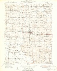
1948 Map of Fairfield
USGS Topo · Published 1948About this map
Fairfield serves as the hub of this rural landscape, situated at the junction of the Southern and Baltimore and Ohio railroads. The late 1940s terrain is characterized by a dense network of one-room schoolhouses and country churches that define the social fabric of Wayne County. Unique educational sites like Pure Gold Sch, Silver Glen Sch, and Walnut Hill Sch are scattered across the prairie, while smaller settlements like Jeffersonville Geff PO and Burnt Prairie PO anchor the outlying districts.
Find a feature on this map
105 named features on this map. Tap any name to fly to it.
Don’t see what you’re looking for? This feature index may not catch every label — zoom into the map to look around manually.
Map Details
Editions of this 1948 Fairfield Map
2 editions found
Other maps of this area

1940 · Carmi
USGS Topo · 1:62,500

1941 · Enfield
USGS Topo · 1:62,500

1942 · McLeansboro
USGS Topo · 1:62,500

1943 · Carmi
USGS Topo · 1:62,500

1943 · Albion
USGS Topo · 1:62,500

1944 · Enfield
USGS Topo · 1:62,500

1945 · McLeansboro
USGS Topo · 1:62,500

1946 · Albion
USGS Topo · 1:62,500

1947 · Wayne City
USGS Topo · 1:62,500

1948 · Flora
USGS Topo · 1:62,500