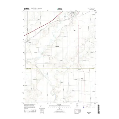
2015 Map of Greenup
USGS Topo · Published 2015About this map
The Embarras River carves a winding path through this central Illinois landscape, defining the topography south of Greenup. This survey documents a rural transition where the northern town centers of the Cumberland Co region give way to the smaller hamlets of Jasper Co at the southern edge. The map reveals a dense network of country roads, such as E 2100th Ave, that link generational landmarks including the Salem Cem, Chezem Cem, and Ward Cem. The interior contains small settlements like Walla Walla and Liberty Hill, while the village of Hidalgo anchors the southeast corner. This cartographic study illustrates the persistence of small agricultural communities and the importance of creek systems like Muddy Creek and Range Cr in shaping local property lines and road placements.
Find a feature on this map
81 named features on this map. Tap any name to fly to it.
Don’t see what you’re looking for? This feature index may not catch every label — zoom into the map to look around manually.
Map Details
Editions of this 2015 Greenup Map
This is the sole edition of this map. No revisions or reprints were ever made.
Other maps of this area

1933 · Toledo
USGS Topo · 1:62,500

1934 · Mattoon
USGS Topo · 1:62,500

1937 · Mattoon
USGS Topo · 1:62,500

1938 · Toledo
USGS Topo · 1:62,500

1940 · Greenup
USGS Topo · 1:62,500

1943 · Greenup
USGS Topo · 1:62,500

1953 · Teutopolis
USGS Topo · 1:62,500

1958 · Decatur
USGS Topo · 1:250,000

1961 · Decatur
USGS Topo · 1:250,000
1984 · Toledo
USGS Topo · 1:24,000