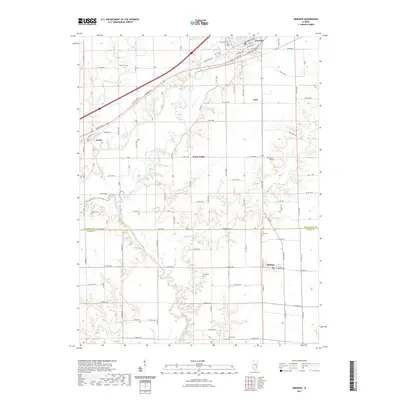
2021 Map of Greenup
USGS Topo · Published 2021About this map
The Embarras River meanders through the central Illinois landscape, carving a path through the borderlands of Cumberland and Jasper counties. This modern topographic survey highlights the community of Greenup, where the historic National Trails Dr and US Rte 40 intersect, reflecting the town's long-standing role as a crossroads. Smaller settlements like Jewett, Hidalgo, and the curiously named Walla Walla are dispersed across the agricultural grid, each connected by a network of county roads. Genealogists and local historians will find significant value in the distribution of family and community burial sites, including Salem Cem, Aten Cem, and Ward Cem, which sit alongside tributaries like Range Cr and Muddy Creek. The transition from Cumberland County to Jasper County is marked by a sudden shift in the rural road numbering system, providing a clear visual record of administrative boundaries and local land division.
Find a feature on this map
56 named features on this map. Tap any name to fly to it.
Don’t see what you’re looking for? This feature index may not catch every label — zoom into the map to look around manually.
Map Details
Editions of this 2021 Greenup Map
This is the sole edition of this map. No revisions or reprints were ever made.
Other maps of this area

1933 · Toledo
USGS Topo · 1:62,500

1934 · Mattoon
USGS Topo · 1:62,500

1937 · Mattoon
USGS Topo · 1:62,500

1938 · Toledo
USGS Topo · 1:62,500

1940 · Greenup
USGS Topo · 1:62,500

1943 · Greenup
USGS Topo · 1:62,500

1953 · Teutopolis
USGS Topo · 1:62,500

1958 · Decatur
USGS Topo · 1:250,000

1961 · Decatur
USGS Topo · 1:250,000
1984 · Toledo
USGS Topo · 1:24,000